Processing Modflow 11 is a graphical user interface designed for flow and transport simulations of surface water and groundwater using MODFLOW, GSFLOW, MT3D-USGS, SEAWAT, MODPATH, and PEST.
It includes built-in support for these models/codes and features a map-based interface that can display online basemaps and GIS shapefiles alongside model grids and results, such as contour maps, flow vectors, and pathlines for multiple models. The interface allows users to construct, calibrate, and run models while also providing tools for result visualization. Additionally, Processing Modflow 11 can import MODFLOW and MT3D models directly from their standard input files.
Below is a list of its key features—scroll down for more details. Click next to an item to display its associated image.
User Guide — Download Software — Recommended Citations — Release Notes
Main Features
World Geographic (With Base Maps)
Cartesian (User-Specified CS)
Supported Models/Codes
MODFLOW-2005 (flow)
MODFLOW-NWT (flow)
GSFLOW (coupled groundwater and surface-water flow model)
MT3DMS (transport)
MT3D-USGS (transport)
SEAWAT (transport)
MODPATH (particle tracking)
ZoneBudget (water budget calculation)
PEST (parameter estimation)
BeoPEST (parallel parameter estimation)
![]() PEST++ (parameter estimation and uncertainty analysis)
PEST++ (parameter estimation and uncertainty analysis)
Model Data Input Tools
Grid Design Tool
Cell-by-Cell Tool
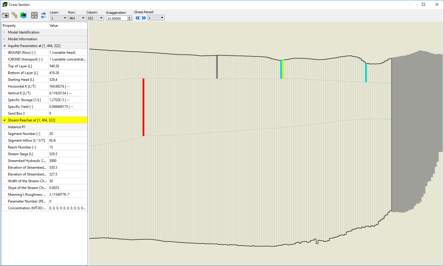
Row/Column Cross-Section Tool
Polygon Tool
Polyline Tool
![]() Pilot Points Tool & Kriging
Pilot Points Tool & Kriging
Model Data Input/Output Formats
2D Matrix
2D Modflow Array
3D Modflow Array
SURFER GRD File
Comma-Separated Values File
ASCII Raster
Shapefile
Image
Video (model animation)
Import Model Input Files1
MODFLOW-1996
MODFLOW-2000/2005
MT3DMS/MT3D-USGS
SEAWAT
Model Discretization2
Up to 200 Layers
Up to 5000 x 5000 cells per layer
Up to 100 transport species
No upper limit on number of stress periods
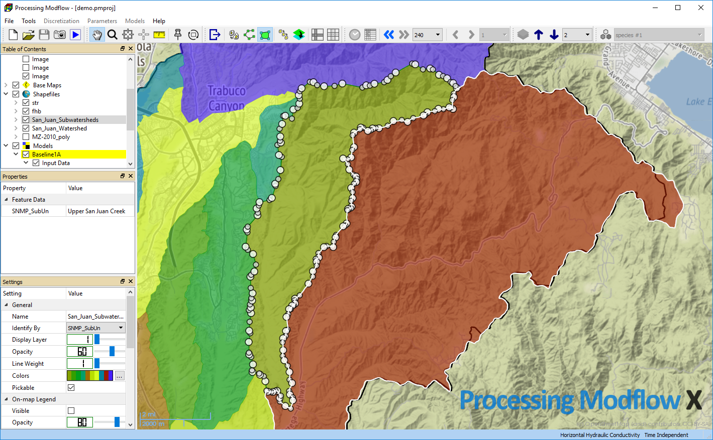
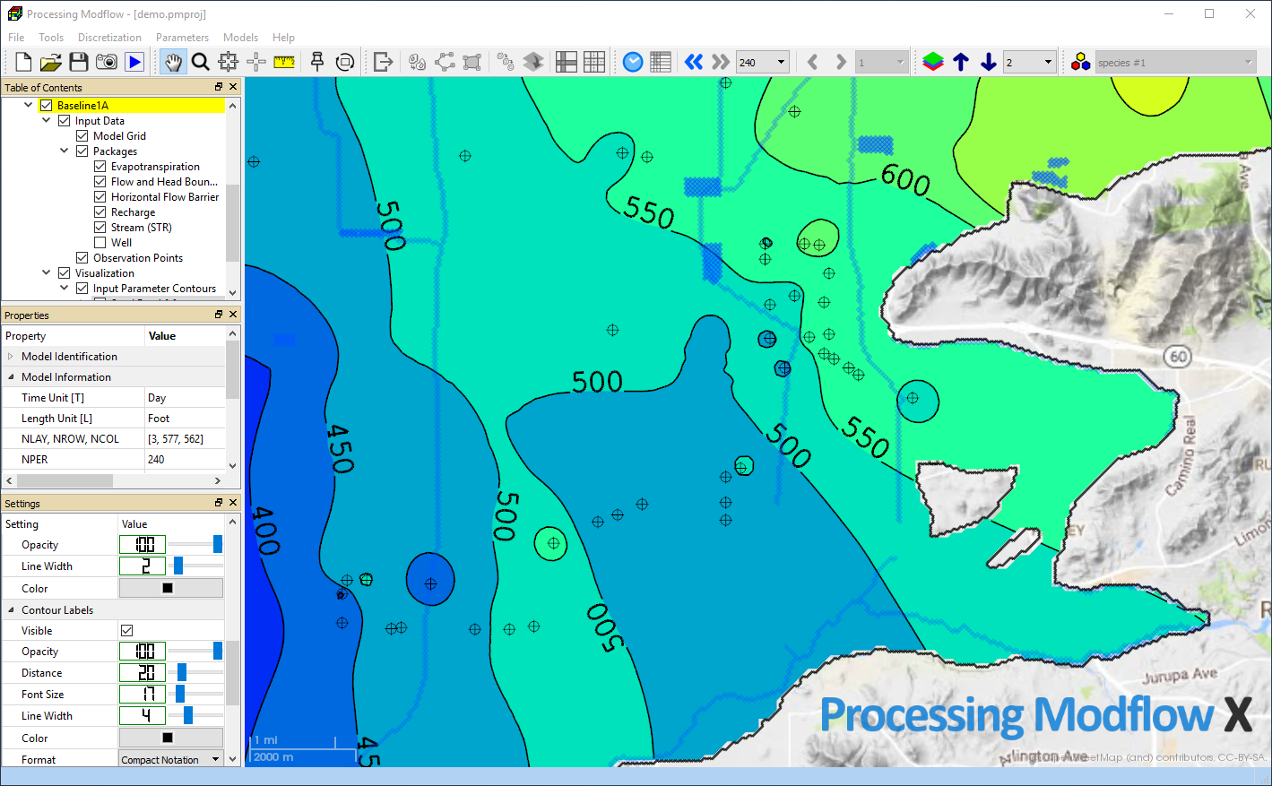
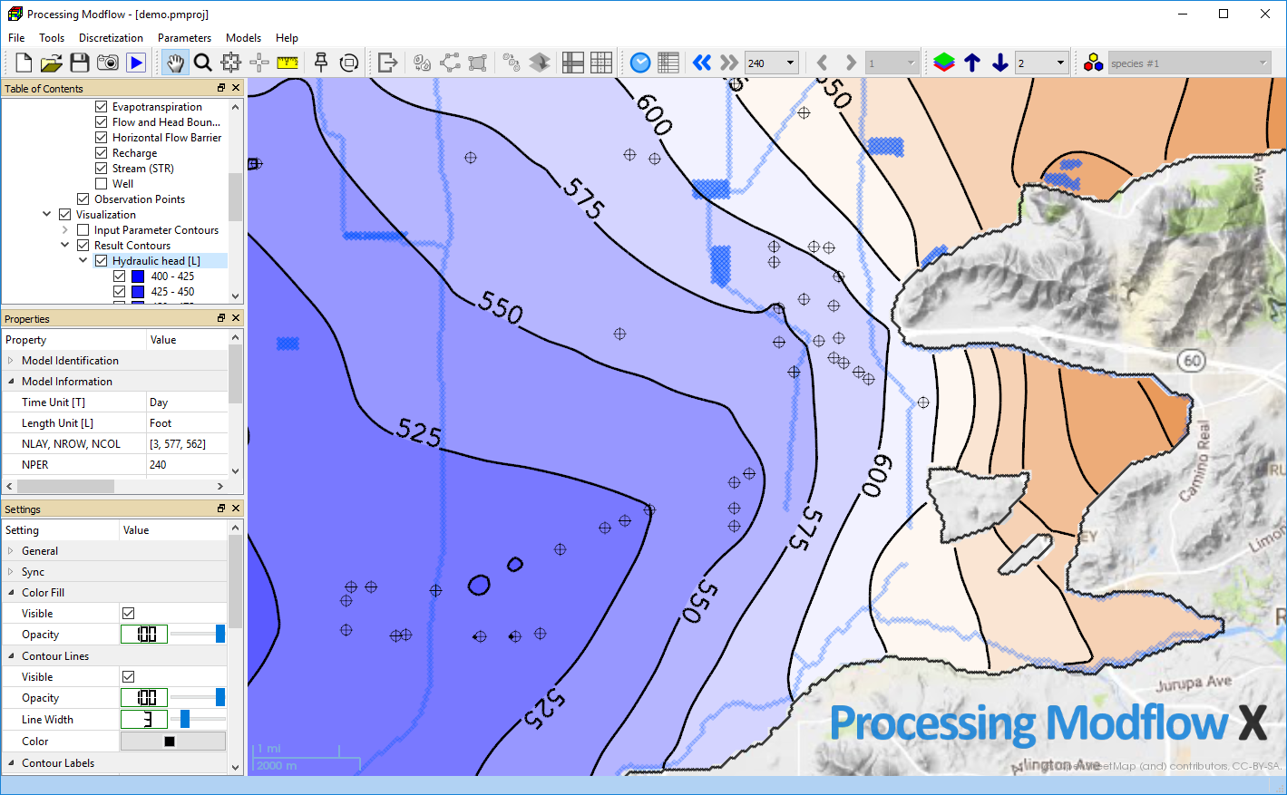
Map Display
Online Basemaps3
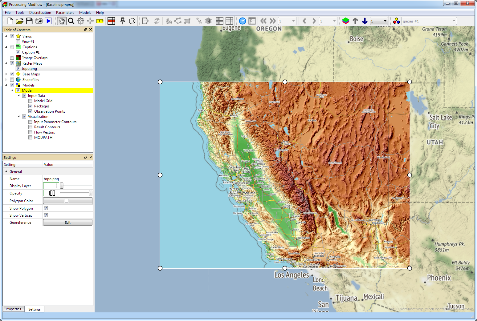
Raster Maps/Offline Basemaps
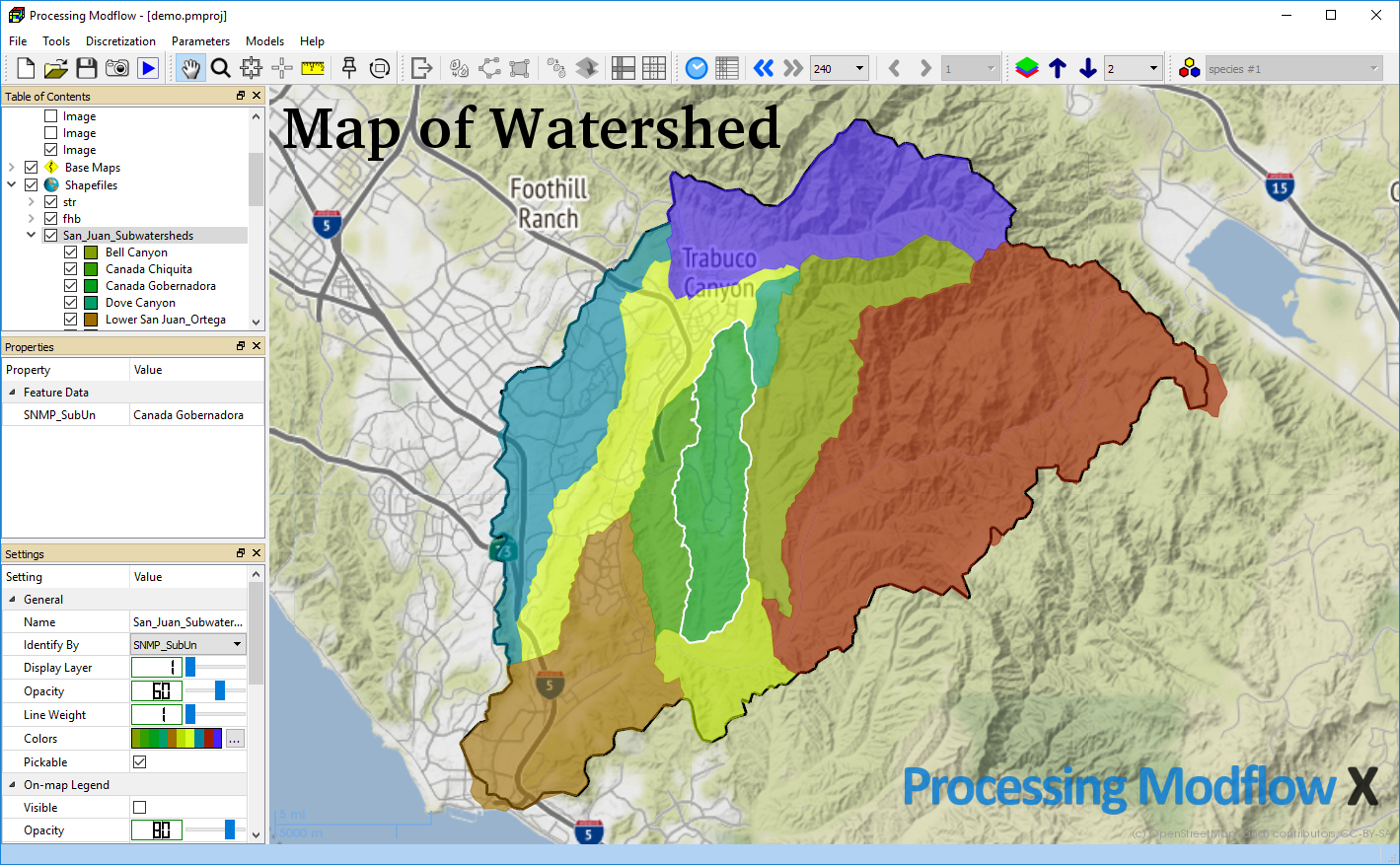
Shapefiles
Image Overlays
Caption Overlays
Observation Points
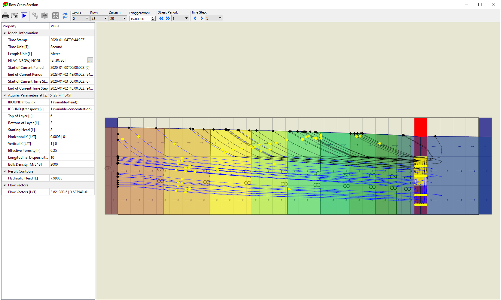
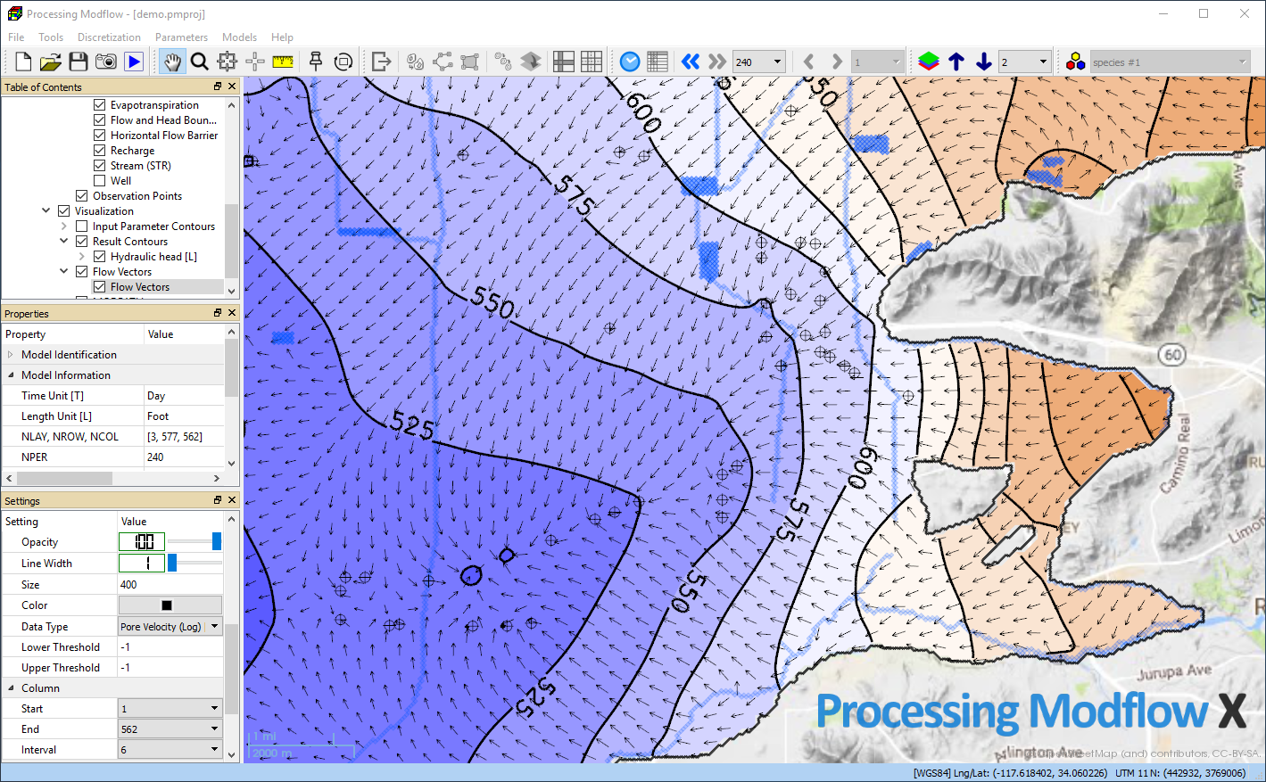
Flow Vectors
Volumetric Flow Rate
Pore Velocity
Darcy Velocity
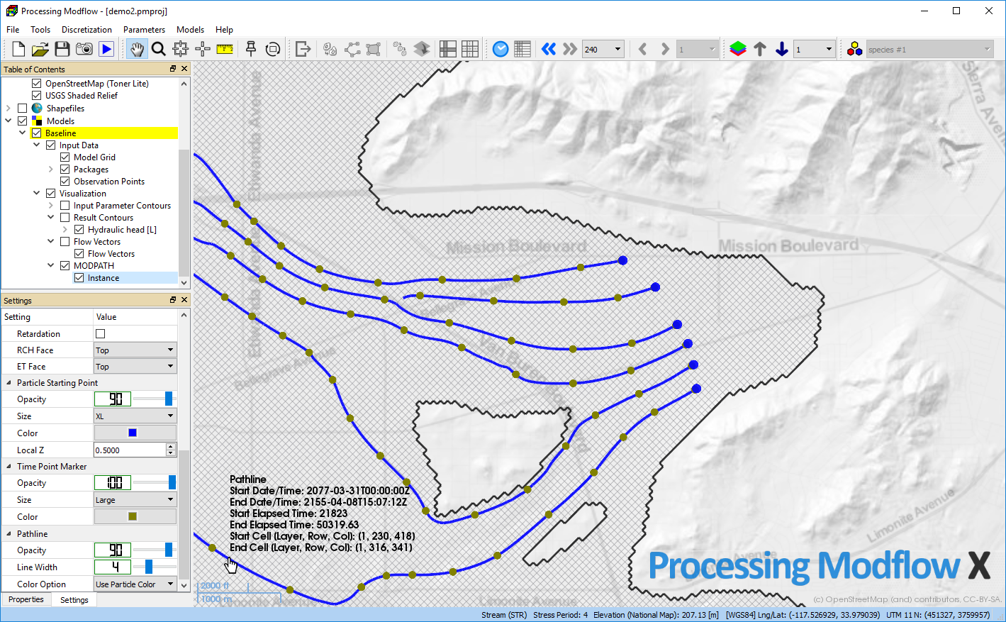
Particle Tracking
Forward or Backward Tracking
Display Particles, Time Marks, End Points, and Pathlines
Layer Elevations
Aquifer Parameters
Recharge Package
Evapotranspiration Package
Dispersion Package
Reaction Package
Sink & Source Mixing Package
Prescribed Fluid Density
Prescribed Dynamic Viscosity
Static Sandboxes – test your data
Transient Sandboxes – animate your data
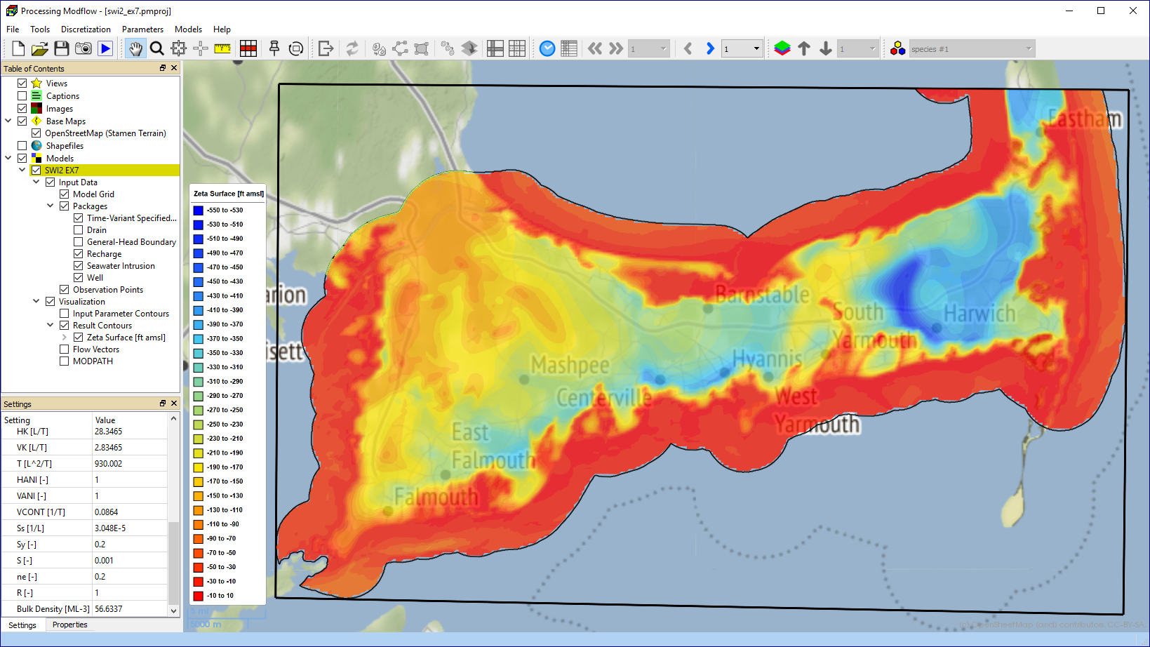
Color-Filled Contours of Model Results
Hydraulic head
Drawdown
Concentration
Cell-by-Cell Flow Terms
Subsidence
Compaction
Seawater-Freshwater Interface (Zeta surface of SWI2)
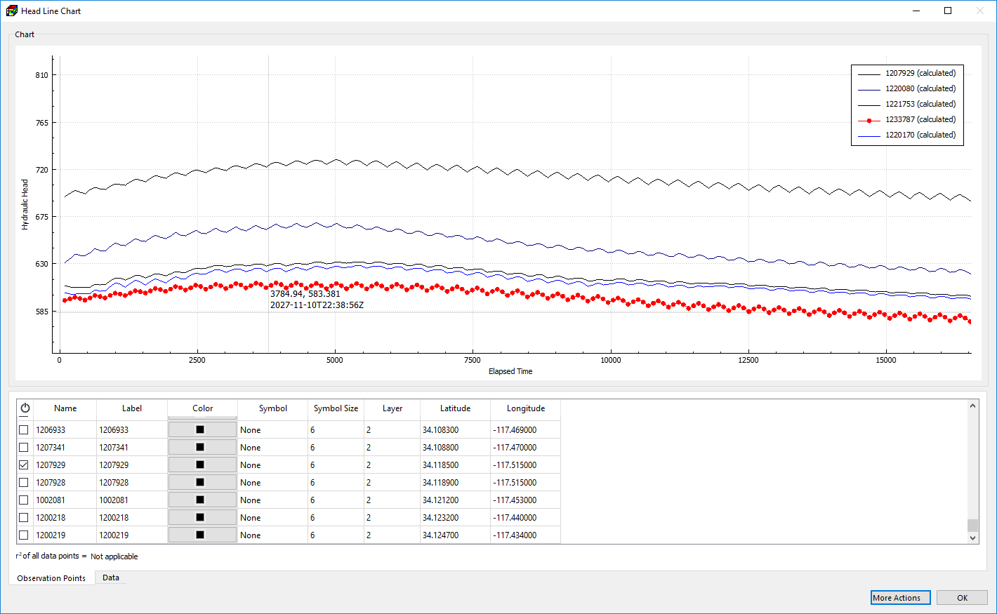
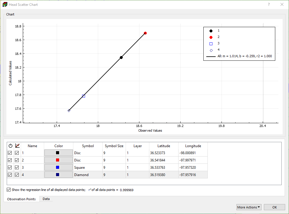
Time Series and Scattered Charts
Hydraulic Head
Drawdown
Concentration
![]() Streamflow
Streamflow
![]() Lake Stage
Lake Stage
MODFLOW-2005 and MODFLOW-NWT
MODFLOW-2005 simulates steady-state and transient groundwater flow in irregularly shaped systems with confined, unconfined, or mixed aquifer layers. It can account for external stresses such as well pumping, areal recharge, evapotranspiration, drain flow, and river interaction. Hydraulic conductivity or transmissivity can vary spatially and be anisotropic, while storage properties may be heterogeneous. The model supports specified head and flux boundaries, as well as head-dependent fluxes along the model boundary. MODFLOW-NWT is an enhanced version of MODFLOW-2005 that uses a Newton-Raphson formulation to more robustly solve unconfined flow problems, particularly those involving drying and rewetting nonlinearities.
The supported packages for both MODFLOW-2005 and MODFLOW-NWT are listed below.
Basic (BAS)
Discretization (DIS)
Output Control (OC)
Flow-Transport Link (LMT)
Internal Flow Packages
Block-Centered Flow (BCF)
Layer-Property Flow (LPF)
Upstream Weighting (UPW)
Boundary Condition Packages
Drain (DRN)
Drain with Return Flow (DRT1)
Evapotranspiration with a Segmented Function (ETS1)
Flow and Head Boundary (FHB)
General-Head Boundary (GHB)
Horizontal-Flow Barrier (HFB6)
Interbed-Storage (IBS)
Lake (LAK3)
Multi-Node Well (MNW1)
Multi-Node Well 2 (MNW2)
Recharge (RCH)
Reservoir (RES1)
River (RIV)
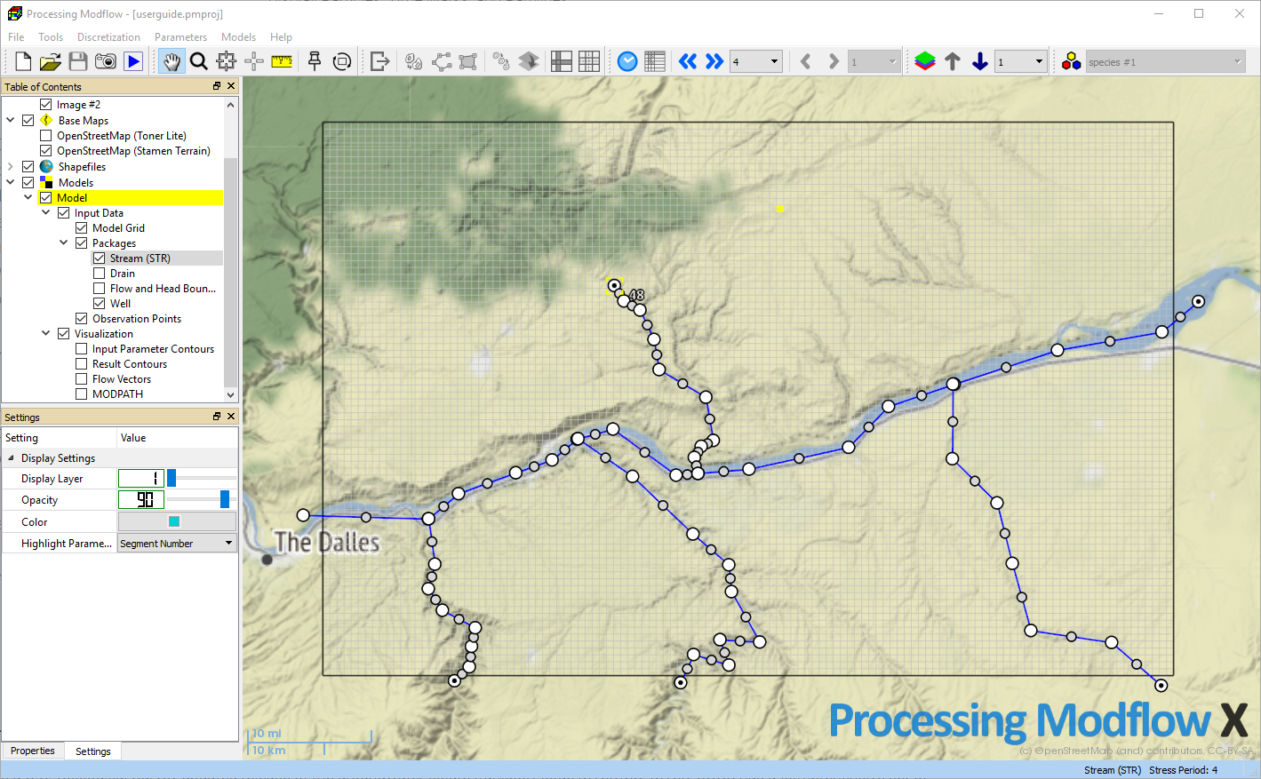
Stream (STR)
Streamflow-Routing (SFR2)
Subsidence and Aquifer-System Compaction (SUB)
Time Variant Specified Head (CHD)
Unsaturated-Flow (UZF1)
Well (WEL)
Solvers
Direct (DE4)
Generic Multigrid (GMG)
Newton (NWT)
Preconditioned Conjugate Gradient (PCG)
PCG with Improved Nonlinear Control (PCGN)
Strongly Implicit Procedure (SIP)
GSFLOW
GSFLOW is a coupled groundwater and surface-water model that integrates the USGS Precipitation-Runoff Modeling System (PRMS-V) with the USGS Modular Groundwater Flow Model (MODFLOW-NWT). It simulates flow across the land surface, within unsaturated and saturated zones, and through streams and lakes—enabling comprehensive modeling of watershed-scale hydrologic processes. GSFLOW is designed to assess the impacts of land-use changes, climate variability, and groundwater withdrawals on surface and subsurface flow. It supports applications from small to large watersheds (a few to several thousand km²) over periods ranging from months to decades.
Supported GSFLOW modules are listed below.
In GSFLOW, a watershed is discretized into Hydrologic Response Units (HRUs) that overlay groundwater model cells. Water is added to and subtracted from each HRU or routed to the underlying groundwater flow model cells based on the water and energy balance that is computed daily for each HRU.
Interception
The Interception Module computes volume of intercepted precipitation, evaporation from intercepted precipitation, and throughfall that reaches the soil or snowpack for individual HRUs.
Potential Evapotranspiration
The following modules can be used to calculate the amount of potential evapotranspiration and determine the state of transpiration in HRUs: potet_hamon (Hamon), potet_hs (Hargreaves-Samani), potet_jh (Jensen-Haise), potet_pan (pan-evaporation), potet_pm_sta (Penman-Monteith), potet_pt (Priestley-Taylor), climate_hru (Predetermined Values).
Precipitation, which can be measured at one or more stations, can be extrapolated to each HRU by one of these modules: precip_1sta, precip_laps, precip_dist2, xyz_dist, ide_dist, climate_hru.
Snow Computation
The Snow Module of GSFLOW/PRMS simulates the initiation, accumulation, and depletion of a snowpack on each HRU.
Soil Zone
The Soil-Zone Module of GSFLOW/PRMS simulates the soil-zone hydrologic processes. Computation of the water content of the soil zone is based on the summation of all moisture depletions and accretions.
Solar Radiation
The Solar Radiation Distribution modules (ddsolrad and ccsolrad) distribute solar radiation to each HRU. The climate_hru module can be used to input solar radiation directly.
The Surface-Runoff Modules (srunoff_smidx and srunoff_carea) compute surface runoff from infiltration excess and soil saturation by using a variable-source-area concept, where the runoff generating areas of the watershed surface vary in location and size over time.
Temperature Distribution
Air temperature is used in computations of evaporation, transpiration, sublimation, and snowmelt for each HRU. Temperature-Distribution Modules compute and distribute maximum, minimum, and average air temperatures for each HRU for each time step. The supported Temperature-Distribution Modules are temp_1sta, temp_laps, temp_dist2, xyz_dist, ide_dist, and climate_hru.
Transpiration
The Transpiration Period modules determine the period of active transpiration for each HRU. The transp_frost module determines whether the current time step is in a period of active transpiration by the killing frost method. The transp_tindex module uses a temperature index method.
MT3DMS, MT3D-USGS, and SEAWAT
MT3DMS is a modular, three-dimensional transport model for simulating advection, dispersion, and chemical reactions of solutes in groundwater systems. MT3D-USGS is an enhanced release by the U.S. Geological Survey, offering expanded capabilities for simulating multispecies solute transport and reactive processes. SEAWAT is a coupled model that integrates MODFLOW and MT3DMS to simulate three-dimensional, variable-density, saturated groundwater flow. Its Variable-Density Flow (VDF) process allows fluid density to vary with solute concentration or pressure, and optionally includes the effects of viscosity, which can depend on solute concentration or temperature.
Although MT3DMS and SEAWAT are not specifically designed for heat transport, temperature can be treated as a solute by assigning appropriate transport coefficients—enabling simultaneous simulation of solute and heat transport.
Supported packages are listed below.
This package is responsible for model discretization and I/O Controls.
Advection (ADV)
This package simulates the transport of miscible contaminants at the same velocity as the groundwater.
Dispersion (DSP)
This package simulates dispersion caused by mechanical dispersion and by molecular diffusion driven by concentration gradients.
GCG Solver Package (GCG)
The GCG Solver is a general-purpose iterative solver based on the generalized conjugate gradient method for solving the system of the transport equations.
This package simulates sorption and reactions.
Supported sorption types include (1) equilibrium-controlled linear and nonlinear sorption (e.g., linear, Freundlich, Langmuir isotherms) and (2) non-equilibrium sorption (first-order reversible kinetic).
Supported reaction types include (1) zero-order reaction (decay, biodegradation, or production), (2) first-order irreversible reaction, (3) first-order chain reaction, (4) Monod kinetic reaction, and (5) instantaneous reactions between one electron donor and one electron acceptor.
Dual-domain mass transfer and custom reactions may also be simulated in MT3D-USGS.
The SFT package of MT3D-USGS simulates one dimensional solute transport in the stream network that is defined by the SFR2 package.
Lake Transport (LKT)
The LKT Package calculates solute concentrations in lakes. The package uses simulated flows calculated by the Lake (LAK3) Package of MODFLOW. Solute entering the lake is instantaneously mixed throughout the entire volume of the lake.
Variable-Density Flow (VDF)
The VDF Process of SEAWAT solves the variable-density ground-water flow equation.
Viscosity (VSC)
The Viscosity package of SEAWAT simulates effects of viscosity variations that are implemented in a modified version of the LPF package.
MODPATH
MODPATH is a particle-tracking post-processing program designed to work with MODFLOW. It employs a semi-analytical tracking scheme, allowing particle flow paths to be analytically calculated within each finite-difference cell. Particles are tracked cell-to-cell until they reach a boundary, internal sink/source, or meet a specified termination condition.
Processing Modflow seamlessly integrates MODPATH with the following options.
Forward or Backward Tracking Directions
Customizable Particle Release Times
Customizable Retardation Factors
Adjustable Tracking Time Steps
Adjustable Tracking Time Limits
Adjustable Particle Stop Options
Particle: Color, Size, Opacity
Time Mark: Color, Size, Opacity
Pathline: Line Width, Opacity, Color by Particle or Layer
Export Pathlines to Shapefile
Export Time Marks to Shapefile
Export Starting Points to Shapefile
Export Starting Points to CSV File
Import Starting Points from CSV File
Zone Budget
Zonebudget is a post-processing tool for computing subregional water budgets using results from the MODFLOW model. Subregions are defined by assigning zone numbers via the Cell-by-Cell, Polyline, or Polygon tools in Processing Modflow. A separate budget is generated for each zone, including flow exchanges with adjacent zones. All three Zonebudget output formats are supported.
This listing file contains the water budget of all zones of individual time steps at which flow terms are saved in the budget file.
For each time, for which the flow terms are saved in the budget file, there is one line for each in-flow term and each out-flow term along with totals. The zones are displayed in columns, so one table displays all zones. This makes it easy to compare any budget term for all the different zones.
This file displays the complete budget for one zone and one time in a single line. Each column has a separate inflow or outflow budget term. The rows can be sorted by time within the spreadsheet program, which makes it possible to easily see how each term changes with time.
PEST, BeoPEST, and PEST++
PEST is the industry-standard software for parameter estimation and uncertainty analysis in complex environmental models. BeoPEST, a parallel version of PEST inspired by Beowulf clusters, runs solution agents on individual CPU cores to accelerate Jacobian matrix computation. When used within Processing Modflow on multicore systems, this significantly speeds up the calibration process.
All PEST++ suite members also support parallelization. Processing Modflow integrates PESTPP-IES![]() and PESTPP-GLM
and PESTPP-GLM![]() . The former works with Pilot Points and Kriging to generate calibration realizations that reflect realistic aquifer parameter distributions.
. The former works with Pilot Points and Kriging to generate calibration realizations that reflect realistic aquifer parameter distributions.
New observation types—Streamflow, Lake Stage, and Multi-layer head/drawdown—can be used with PEST, BeoPEST, and PEST++. The set of estimable aquifer parameters depends on the chosen internal flow package and layer types. Parameters can be calibrated as zones of uniformity or using the Pilot point method. See the user guide for details.
Horizontal hydraulic conductivity
Vertical hydraulic conductivity
Horizontal anisotropy
Vertical anisotropy
Vertical leakance
Storage coefficient
Specific storage
Specific yield
Transmissivity
Drain (DRN) Package
Drain conductance
Drain with Return Flow (DRT) Package
Drain conductance
Evapotranspiration (EVT) Package
Maximum ET Flux and/or
![]() Array Multiplier of Maximum ET Flux
Array Multiplier of Maximum ET Flux
Maximum ET Flux and/or
General-Head Boundary (GHB) Package
Boundary conductance
Horizontal-Flow Barrier (HBF) Package
Hydraulic characteristic
Interbed Storage (IBS) Package
Inelastic Storage Factor
Lake (LAK3) Package
Lakebed Leakance
Recharge (RCH) Package
Recharge flux and/or
![]() Array Multiplier of Recharge flux
Array Multiplier of Recharge flux
Riverbed conductance
Reservoir (RES1) Package
Vertical hydraulic conductivity of reservoir bed
Stream (STR) Package
Streambed conductance
Streamflow-Routing (SFR2) Package
Streambed hydraulic conductivity
Unsaturated-Zone Flow (UZF1) Package
Infiltration rate
Well (WEL) Package
Flow rate
System Requirements
Windows 11
Windows 10
Windows 7 (deprecated)
Processors
64-bit
8 GB or more.
Hard Disk
2 GB for the application and examples. Significant more storage may be required by larger models. Solid state drives recommended.
Supports OpenGL 2.1 or higher4
Internet Connection
Required for licensing and online basemaps
Notes
1 Native input data files of supported packages may be imported, except for the OC and LMT packages. Other restrictions may apply, for example SFR2 defined with parameters are not supported.
2 The model discretization limit subjects to the available physical resources of the computer, such as memory, disk space, and CPU speed. In general, the number of cells and layers of a model should be kept as small as possible. Unnecessary use of excessively large number of cells is not advised.
3 See here or here for lists of supported basemaps.
4 Most 3D graphics adapters are supported. To test the compatibility of your graphic adapter, download and run the Processing Modflow on your computer. If the application starts successfully, your graphics adapter is supported.